Today In History The Berlin Conference Did Not Draw Uganda’s Borders — But Its Decisions Reached The Rwenzori
+256 702 23 93 37: On 15 November 1884, European powers gathered in Berlin to establish rules governing their expanding interests in Africa. The meeting did not draw Uganda’s modern boundaries, as popular accounts sometimes suggest. But the diplomatic system it helped legitimise set the stage for treaties, territorial rivalries and boundary surveys that eventually shaped Uganda’s frontier with the Democratic Republic of Congo.

UgandaToday: Today In History The Berlin Conference Did Not Draw Uganda’s Borders — But Its Decisions Reached The Rwenzori

On 15 November 1884, European powers gathered in Berlin to establish rules governing their expanding interests in Africa. The meeting did not draw Uganda’s modern boundaries, as popular accounts sometimes suggest. But the diplomatic system it helped legitimise set the stage for treaties, territorial rivalries and boundary surveys that eventually shaped Uganda’s frontier with the Democratic Republic of Congo.
Today In History: The Uganda Today Historical Perspective
15 November 1884
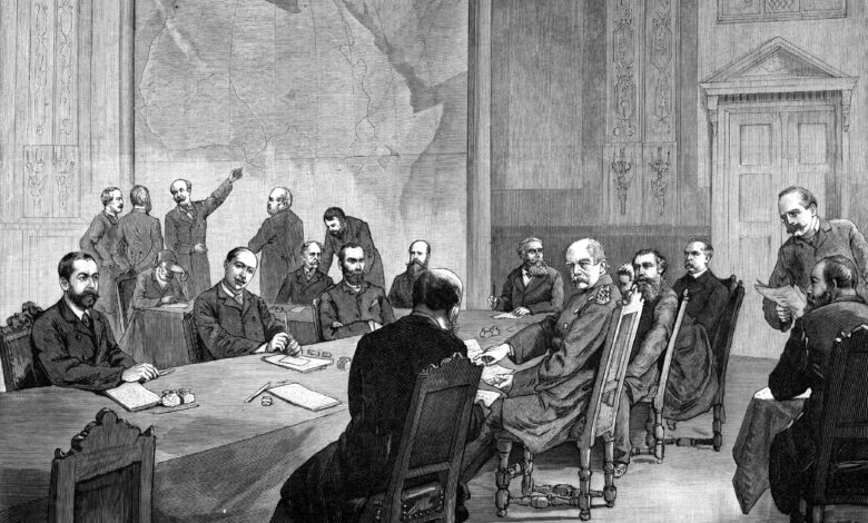
Today marks 142 years since the opening of the Berlin West Africa Conference, a gathering that remains one of the most consequential episodes in the history of European colonial expansion in Africa.
The meeting was convened by German Chancellor Otto von Bismarck in Berlin. Representatives of 14 states, including European powers, the United States and the Ottoman Empire, assembled to discuss trade, navigation and competing territorial interests in Africa.
There was one glaring absence: African representatives were not consulted.
The meeting was held at a time when European commercial and political interests were moving increasingly inland from Africa’s coastal trading centres. Rival claims, particularly around the Congo River basin, threatened to bring European powers into conflict with one another.
The conference sought to establish a framework for managing those rivalries. Its implications would extend far beyond the Congo basin, influencing the wider process through which European powers expanded their control over African territories.
The Myth That Africa Was Divided With A Ruler In Berlin
The Berlin Conference is often portrayed as the meeting at which European leaders sat around a map and divided the entire African continent into the national boundaries seen today.
That familiar picture captures the injustice of colonial exclusion, but it is not an accurate description of what happened.
The conference did not draw Uganda’s boundaries, nor did it produce a complete map allocating every African territory to a European power.
Its proceedings concentrated on freedom of trade in the Congo basin, navigation on the Congo and Niger rivers, and the conditions under which European powers could announce and establish territorial claims.
The General Act was eventually signed on 26 February 1885. Among its most consequential provisions were Articles 34 and 35, which dealt with notification of new coastal occupations and the principle of effective occupation.
In practical terms, European powers could no longer rely merely on symbolic gestures, such as raising a flag, to substantiate certain territorial claims. They increasingly had to demonstrate an administrative and political presence.
The German Federal Foreign Office’s historical archive describes these provisions as helping establish a framework for European colonial expansion into the African interior.
However, the exact influence of Berlin on the drawing of Africa’s modern borders remains a subject of historical debate.
A study by Jack Paine, Xiaoyan Qiu and Joan Ricart-Huguet, published in the American Political Science Review in February 2025, argues that the conference had limited direct influence on most African borders. Their research finds that many boundaries were established through later bilateral negotiations, treaties and investigations of local conditions.
The authors argue that historical political frontiers and major water bodies influenced many of the borders that eventually emerged.
The distinction is important: Berlin helped shape the rules and atmosphere of imperial competition, but much of the actual boundary-making happened later, on the ground and through subsequent negotiations.
How Uganda Entered The Colonial Negotiations
Uganda’s connection to the Berlin process becomes clearer when the subsequent agreements between Britain, Germany and King Leopold II of Belgium are examined.
On 1 July 1890, Britain and Germany signed the Anglo-German Treaty, commonly known as the Heligoland-Zanzibar Treaty. It settled competing colonial interests in East Africa and placed the territories associated with Uganda within the British sphere of influence.
The treaty also recognised German control over what became Tanganyika, while Britain ceded the North Sea island of Heligoland to Germany.
Uganda itself was not simply handed over by the Berlin delegates. Its position emerged through a series of later diplomatic arrangements and British actions in the region.
A particularly important agreement followed on 12 May 1894.
Britain and King Leopold II, sovereign of the Congo Free State, signed an agreement in Brussels defining their respective spheres of influence in East and Central Africa.
The agreement used the 30th meridian east of Greenwich and the Congo-Nile watershed as important geographical reference points. It also involved arrangements concerning territory in the western Nile basin.
On 18 June 1894, Britain formally declared a protectorate over Buganda, with protectorate rights subsequently extended to neighbouring territories that came to form Uganda.
These developments demonstrate how Uganda’s colonial future was shaped not by one conference, but by a succession of European agreements and decisions.
The Rwenzori Mountains Became Part Of A Much Longer Border Story

One of the most revealing consequences of these negotiations concerns the Uganda-Congo boundary.
Today, the frontier between Uganda and the Democratic Republic of Congo runs through a landscape of mountains, rivers, lakes and drainage divides.
The Rwenzori Mountains, the Semliki River, Lake Edward and Lake Albert are among the geographical features associated with the boundary.
But the line was not established in its present form at Berlin.
The United States Department of State’s International Boundary Study No. 108, published on 15 December 1970, records that a Uganda-Congo boundary commission was organised between 1906 and 1908 to map sections of the frontier.
A further agreement was reached in 1910, followed by an Anglo-Belgian agreement signed on 3 February 1915. Ratifications of the 1915 agreement were exchanged in London on 20 October 1919.
The 1915 agreement formally recognised the boundary as determined through earlier surveys and negotiations. Its detailed description includes Mount Sabinio, the Ishasha River, Lake Edward, the Rwenzori range, Margherita Peak, the Lami River and the Semliki River.

library.law.fsu.edu
In other words, the border that appears on today’s map was the outcome of a long process involving imperial diplomacy, field surveys and geographical interpretation.
African Communities Were Not Simply Passive Observers

There is another important dimension to this history: the role played by Africans living in the territories being claimed.
The absence of African representatives from the Berlin Conference should not be mistaken for an absence of African agency throughout the subsequent process of colonial boundary-making.
A 2025 doctoral thesis by Francesco Moze at the University of Edinburgh, titled Marking The Confines Of Empire: The Historical Geographies Of The Uganda-Congo Boundary, 1885–1915, examines how the frontier evolved.
Its publicly available abstract argues that the Uganda-Congo boundary changed not only because of diplomatic negotiations and cartographic mistakes, but also because of the actions and strategies of indigenous people living in the borderlands.
Moze describes how instruments of colonial power — including flags, uniforms, firearms, religious objects, currency and boundary pillars — became part of the process through which imperial authority was asserted and contested.
This is a significant perspective because it moves the story away from the assumption that European officials alone determined every aspect of the frontier.
The full thesis is currently restricted, so this article does not attribute particular actions to named individuals or communities without access to the detailed research. Nevertheless, its abstract points to an important historical argument: people living in the borderlands were not merely spectators to the making of the boundary.
The People And Landscapes Behind The Colonial Maps
The colonial-era exploration of the Rwenzori region also reveals how European expeditions depended on African knowledge and labour.
In 1906, the Italian Duke of Abruzzi led an expedition into the Rwenzori Mountains, accompanied by photographer Vittorio Sella.
The expedition travelled from Entebbe towards Fort Portal, using Baganda porters along the route. As it approached the mountains, local Bakonzo porters were brought in because of their familiarity with the difficult terrain.
Sella’s photographs documented the expedition, the people who supported it and the mountain landscape. They offer a valuable visual record of the region during the period when colonial authorities were increasingly interested in mapping and understanding the interior.
These photographs are not records of the boundary negotiations themselves. They nevertheless help illustrate the people and terrain that European officials and surveyors were attempting to understand and administer.
Why This History Still Matters To Uganda And Africa
The Berlin Conference remains important not simply because of what European powers discussed in 1884 and 1885, but because of the political system of colonial competition that followed.
For Uganda, the subsequent treaties and surveys helped determine the country’s relationship with neighbouring territories, including the Congo, Rwanda, Tanzania, Kenya and South Sudan.
The Uganda-Congo boundary is particularly instructive. Its present alignment reflects negotiations and technical work carried out over several decades, rather than a single decision made in a European conference room.
For communities living around the Rwenzori Mountains, the Semliki region and the western borderlands, the frontier is more than a line on a map. It is part of a landscape of livelihoods, trade, family connections, movement and shared natural resources.
The lesson for contemporary Africa is that borders must be understood through their histories, not merely accepted as lines inherited from colonial maps.
The continent’s history is also more complex than the story of European officials dividing land among themselves. African rulers, communities and local actors negotiated, resisted and sometimes influenced the territorial arrangements that emerged.
On 15 November 1884, the doors opened in Berlin to a conference from which Africans were excluded. But the history of the boundaries that followed was not written in Berlin alone.
It was also written in the African interior — along rivers, mountain ridges, trading routes and communities whose histories deserve to be remembered.
Editorial Accuracy Note: The Berlin Conference did not draw Uganda’s modern borders. The article deliberately distinguishes the 1884–1885 conference from the subsequent 1890, 1894, 1910 and 1915 agreements and boundary surveys. The 1915 agreement was signed on 3 February 1915, with ratifications exchanged on 20 October 1919. The local African agency argument is attributed to the publicly available abstract of Moze’s research, rather than presented as a fully documented account of individual incidents.
Sources And Research Notes
1. German Federal Foreign Office, Political Archive: General Act Of The Berlin West Africa Conference, 26 February 1885. Provides the conference dates, participating states, objectives and explanation of Articles 34 and 35.
Federal Foreign Office
2. Jack Paine, Xiaoyan Qiu and Joan Ricart-Huguet: “Endogenous Colonial Borders: Precolonial States and Geography in the Partition of Africa”, American Political Science Review, published online 7 March 2024 and in Volume 119, Issue 1, February 2025. Offers a scholarly reassessment of the claim that the Berlin Conference directly drew Africa’s modern borders.
Cambridge Core+1
3. United States Department of State, Office of the Geographer: International Boundary Study No. 108: Democratic Republic Of The Congo–Uganda Boundary, 15 December 1970. Provides the historical sequence and detailed geographical description of the present boundary.
library.law.fsu.edu+1
4. Francesco Moze: Marking The Confines Of Empire: The Historical Geographies Of The Uganda-Congo Boundary, 1885–1915, University of Edinburgh, 2025. The publicly available abstract provides a recent interpretation of indigenous agency in the making of the boundary; the full thesis is restricted until 10 July 2027.
era.ed.ac.uk
5. German History In Documents And Images: The Anglo-German Treaty, commonly called the Heligoland-Zanzibar Treaty, signed on 1 July 1890.
German History in Documents and Images
6. British Parliamentary Hansard: Treaty Series No. 15, 1894, recording the agreement between Britain and King Leopold II signed on 12 May 1894.
api.parliament.uk
#UgandaToday #PhoenixNewsFeeds #OperaNewsFeeds #TodayInHistory #UgandaHistory #AfricanHistory